GeoWGS84 Corp Acquires LizardTech Suite of Products, Including GeoExpress and the MrSID Format. Click here for details
Vector
Vector files are a fundamental data format in Geographic Information Systems (GIS), used to represent geographic features with high precision through three primary geometric elements: points, lines, and polygons. Points are used to map discrete locations such as wells, utility poles, landmarks, or survey markers. Lines represent linear features like roads, railways, rivers, pipelines, and power lines, while polygons define enclosed areas such as land parcels, lakes, forests, administrative boundaries, and buildings. Unlike raster data, vector data stores exact coordinates, enabling accurate measurement of distances, areas, and perimeters without loss of quality when scaled. Each vector feature can also contain descriptive attributes, such as names, classifications, ownership details, or population statistics, allowing spatial and attribute data to be analyzed together. Vector files are widely used in cartography, urban planning, transportation, environmental management, land administration, utility mapping, and infrastructure development, providing a reliable foundation for visualization, geospatial analysis, and informed decision-making.
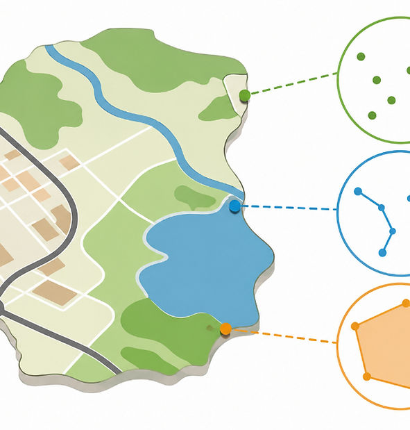
Vector data represents geographic information using mathematical geometry rather than a grid of pixels. Instead of storing images as individual cells, it uses points to represent specific locations, lines to depict linear features such as roads, rivers, and utility networks, and polygons to define areas like land parcels, lakes, forests, and administrative boundaries. Because vector features are defined by precise coordinates, they can be enlarged or reduced without losing quality, making them highly accurate and scalable. This precision allows for detailed spatial analysis, accurate distance and area measurements, and efficient data storage compared to raster formats. Vector data also supports attribute information, enabling each feature to store descriptive details such as names, classifications, ownership, or population. These characteristics make vector data the preferred choice for applications including digital cartography, GPS navigation, land surveying, urban planning, infrastructure management, environmental modeling, and Geographic Information Systems (GIS), where reliable, high-precision geographic representation and analysis are essential.
For more information or any questions regarding our services, please don't hesitate to contact us at
Email: info@geowgs84.com
USA (HQ): (720) 702–4849
India: 9009471866 - Jay Sharma
Canada: (519) 590 9999
Mexico: 55 5941 3755
UK & Spain: +44 12358 56710