GeoWGS84 Corp Acquires LizardTech Suite of Products, Including GeoExpress and the MrSID Format. Click here for details

FACILITIES MANAGEMENT
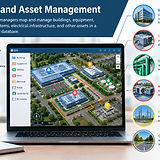
Facility and Asset Management - GIS helps facility managers map and manage buildings, equipment, utilities, HVAC systems, electrical infrastructure, and other assets in a centralized spatial database.
The use of UAVs, otherwise known as drones, is becoming popular in facilities management, where they are applied in inspection, monitoring, and maintenance of buildings and other structures. Drones have high-resolution cameras, thermal sensors, LiDAR, and many other technologies that can be used to collect data while minimizing manual inspections in challenging situations.
Key Applications of Drones in Facilities Management
Building and Roof Inspection: Drones can produce high-resolution imagery of rooftops, walls, façades, and any other exterior surfaces of building structures. Facility managers can be able to analyze the imagery and determine any potential problems such as cracks, water leakage, corrosion, structural damages, etc.
Safety and Security Monitoring: Large-scale facilities such as industrial plants, warehouses, construction sites, ports, and commercial premises can be monitored with the use of drones regularly. In this way, facility managers can be able to identify any potential hazards, security breaches, and damages to the structure.
Energy Auditing: The drones equipped with thermal cameras can be used to identify temperature differences and energy leaks in buildings and industrial facilities.
Preventive Maintenance: Unmanned aerial vehicles can frequently monitor important infrastructure like pipelines, solar panels, wind turbines, communication towers, and other equipment. Multiple drone inspections can reveal any wear and tear, damage, or malfunctions, which can be repaired ahead of time to prevent future equipment failure and additional expenses caused by equipment downtime.
Access to Difficult Areas: The main strength of drones is that they can fly to places that would otherwise be hard or even dangerous for humans to reach. These include roofs, elevated or tall infrastructure elements, high-voltage equipment, towers, etc. Using drones will minimize the safety risk for workers and allow obtaining valuable information.
Drone Regulations and Safety
The use of drones in facilities management is subject to aviation laws and safety measures. Depending on the country, the commercial pilots who use drones need to have proper certificates, insurance, and permissions. Other factors that should be considered when organizing drone inspections include airspace restrictions, privacy considerations, safety procedures at a particular facility, etc.
Combining aerial imagery, LiDAR, thermal data, and other types of sensors with GIS and asset management will improve the inspection process in facilities management.
Facility and Asset Management - GIS helps facility managers map and manage buildings, equipment, utilities, HVAC systems, electrical infrastructure, and other assets in a centralized spatial database.
Space and Floor Management - GIS can visualize floor plans, rooms, workspaces, occupancy, and available areas, helping organizations optimize space utilization and support workplace planning.
Maintenance and Inspections - Facility teams can use GIS to locate assets, track maintenance activities, identify problem areas, and schedule inspections based on asset location and condition.
Emergency and Safety Management - GIS supports emergency planning by mapping evacuation routes, fire exits, emergency equipment, access points, and hazardous areas, helping teams respond more effectively to incidents.