GeoWGS84 Corp Acquires LizardTech Suite of Products, Including GeoExpress and the MrSID Format. Click here for details
Drone Mapping: All you need to know
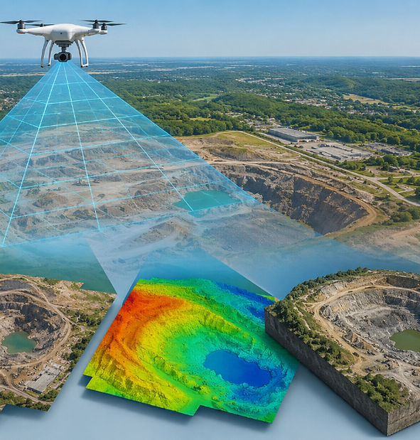
Drone mapping is an advanced surveying method that uses high-resolution drones to capture detailed aerial images and geospatial data of land, buildings, and large-scale areas. This technology enables fast, accurate, and cost-efficient mapping compared to traditional ground surveying techniques. It is widely used across industries such as construction, agriculture, real estate, mining, and infrastructure development for planning, monitoring, and analysis.
By processing drone-captured data, professionals can generate highly accurate outputs such as orthomosaic maps, digital elevation models (DEMs), digital surface models (DSMs), and 3D photogrammetric models. These deliver precise spatial insights that help in measuring distances, calculating volumes, assessing terrain, tracking land changes, and identifying site conditions with greater efficiency.
Drone mapping also improves safety by reducing the need for manual fieldwork in hazardous or hard-to-reach areas. With rapid data collection and advanced analytics, it supports better decision-making, improves project timelines, and enhances overall operational productivity across various sectors.
With its ability to cover vast areas in a short time, drone mapping greatly improves planning, monitoring, and decision-making processes. It enhances overall project efficiency by speeding up data collection and reducing the need for manual surveys. This technology also helps lower operational costs while delivering highly accurate measurements and detailed analysis.
Drone mapping is widely used in land assessment, construction site inspection, agriculture, mining, and infrastructure development. It provides precise geospatial data that supports better visualization of terrain and site conditions, helping engineers and planners make more informed decisions.
By capturing high-resolution aerial imagery and generating accurate maps, drone mapping ensures better progress tracking and quality control throughout project lifecycles. It minimizes human error, improves safety by reducing the need for on-site inspections in risky areas, and supports faster response to potential issues.
For more information or any questions regarding our services, please don't hesitate to contact us at
Email: info@geowgs84.com
USA (HQ): (720) 702–4849
India: 9009471866 - Jay Sharma
Canada: (519) 590 9999
Mexico: 55 5941 3755
UK & Spain: +44 12358 56710