GeoWGS84 Corp Acquires LizardTech Suite of Products, Including GeoExpress and the MrSID Format. Click here for details
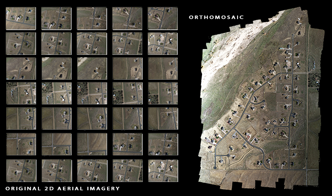
Drone aerial image data collection down to ~2 cm resolution
Worldwide experienced professional drone aerial imagery data and LiDAR acquisition services
Worldwide DPN (Drone Partner Network) of certified experienced drone pilots
Quick turnaround
Large drone imaging coverages are possible using fixed-wing drones
Huge cost savings
Use PPK or RTK systems along with GCPs and checkpoints to ensure your accuracy specifications
Ground Control Points (GCPs) and checkpoints for better verifiable accuracy
Perform drone inspection services in a large variety of industries, both outdoor and indoor

Drone Aerial Image Data Acquisition Services
We can help with
Drone aerial image data collection down to ~2 cm resolution
Worldwide experienced professional drone aerial imagery data and LiDAR acquisition services
Worldwide DPN (Drone Partner Network) of certified experienced drone pilots
Quick turnaround
Large drone imaging coverages are possible using fixed-wing drones
Huge cost savings
Use PPK or RTK systems along with GCPs and checkpoints to ensure your accuracy specifications
Ground Control Points (GCPs) and checkpoints for better verifiable accuracy
Perform drone inspection services in a large variety of industries, both outdoor and indoor
Our Drones
WingtraOne’s ability to fly for long periods at a time allows you to minimize your number of flights to get more work done, allowing you to begin processing and analyzing your images faster.
The WingtraOne is able to capture horizontal absolute accuracy, down to 1 cm (0.4 in) and vertical absolute accuracy down to 3 cm (1.2 in) in many circumstances.
With a full-frame 42 MP Sony RX1R II camera and a multi-frequency PPK GNSS receiver, WingtraOne delivers best-in-class absolute accuracy.
Some of the best image quality in the industry for the highest map quality and accuracy.
Take off and land vertically (VTOL) allowing for collecting data almost anywhere.
Fly everywhere and avoid damaging your drone in belly landings. WingtraOne is able to take off and land like a quadcopter drone and then fly like long distances like a fixed-wing aircraft.
WingtraOne is great for saving time on your project collections.
The Phantom 4 RTK is a rugged, reliable and smart mapping and imaging drone with highly accurate mapping functions. The aircraft has a built-in DJI Onboard D-RTKTM, which provides precision data for centimeter-level positioning accuracy. Multi-directional obstacle sensing achieved through vision and infrared sensors enables intelligent obstacle avoidance during flight and indoor hovering and flight. The Phantom 4 RTK records videos at 4K and captures 20 megapixel photos. The OCUSYNCTM HD video downlink built into both the aircraft and remote controller ensures a reliable and stable transmission.
Combining the Phantom 4 RTK with a RTK base station and ground control points during image collection ensures that you mapping specifications will
Skydio X2E is the ultimate intelligent drone for enterprise applications. X2E pairs breakthrough autonomy software with a rugged, foldable airframe making for easy transportation anywhere, a thermal camera, and approximately 35 minutes of flight time. The X2E is equipped with six 4K navigation cameras for 360° obstacle avoidance critical for close inspection work and a dual sensor payload that includes 12MP color and 320x256 FLIR® sensors. From situational awareness and asset inspection to security and patrol use cases, X2E enables enterprises, first responders, and civilian agencies to safely ramp their drone fleets with minimal training, removing all barriers to enter the drone easy deployment for multiple uses. Designed, assembled, and supported in the USA, X2E provides a higher degree of supply chain security.
Please click to download the sample
We welcome your inquiries for Drone image collection and processing.
"We partner with the best companies worldwide to bring you high quality and accurate data"