
ArcGIS Pro Explained: Key Features, Tools, and Capabilities

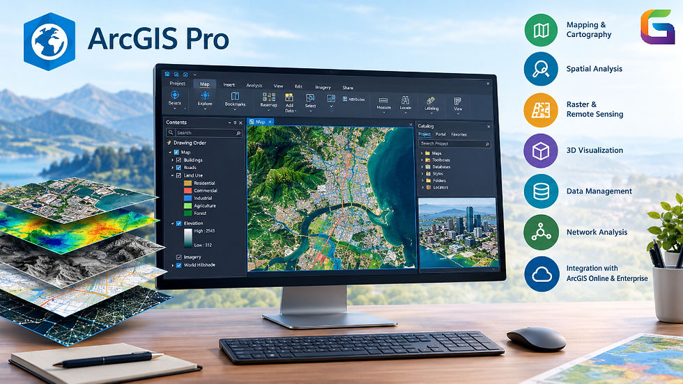
ArcGIS Pro is a professional-grade geographic information system (GIS) software, designed by Esri to create, manage, analyze, and visualize geospatial information. The software offers a complete solution for handling vector data, raster images, 3D objects, terrain layers, and spatial databases. Professionals in GIS employ ArcGIS Pro to reveal geographic relationships, conduct spatial analysis, create maps, and make informed decisions using geospatial information.
In contrast to conventional desktop mapping software, ArcGIS Pro enables 2D and 3D visualization capabilities, geoprocessing tasks, remote sensing operations, and interoperability with ArcGIS Online and ArcGIS Enterprise. ArcGIS Pro provides a project-based interface for arranging maps, layouts, databases, toolboxes, and other GIS tools in one project.
What Is ArcGIS Pro Used For?
ArcGIS Pro can be used in many different applications, including:
GIS Mapping: Develop thematic maps, reference maps, and map compositions.
Spatial Analysis: Establish spatial relationships, proximity, patterns, and distributions.
Remote Sensing: Conduct analysis on satellite images, aerial photographs, and raster data.
Terrain Modeling: Conduct analysis on elevation, slope, aspects, watersheds, and other surface properties.
3D Visualization: Create 3D scenes that incorporate terrain and buildings along with other geographic elements.
Data Management: Manage, edit, validate, and maintain spatial databases.
Network Analysis: Assess routes, service areas, accessibility, and transport networks.
Automation: Automate geoprocessing through Python and ModelBuilder.
These applications of ArcGIS Pro make it suitable for use in fields such as urban planning, environmental monitoring, agriculture, transportation, utilities, disaster management, and infrastructure development.
Key Features of ArcGIS Pro
2D Mapping and Cartographic Design
Tools are included within ArcGIS Pro for the production of comprehensive 2D maps by making use of vector, raster, and tabular data layers. Geographic features may be symbolized based on their attributes, classified into logical categories, and depicted by means of graduated color or proportional symbols.
The software offers cartographic tools for labeling, scale-based symbol visibility, map series, coordinate grids, map frames, legends, and layout design.
Common applications of ArcGIS Pro maps include:
Creating land-use and land-cover maps.
Showing population distribution.
Creating maps of roads and utilities.
Making topographic and thematic maps.
Creating map layouts for reports and professional documents.
Map projections may be set in ArcGIS Pro by making use of different geographic and projected coordinate systems.
Advanced Spatial Analysis
One of the key skills of ArcGIS Pro is spatial analysis. Its geoprocessing tools allow assessing spatial relationships, calculating distances, revealing patterns, and obtaining new information from already existing datasets.
Some of the most commonly used spatial analysis tools are:
Buffer: Creates buffered zones around geographic objects at certain distances.
Clip: Cuts out objects that lie inside a certain boundary.
Intersect: Reveals overlapping zones or objects from several input layers.
Spatial Join: Applies attributes from one dataset to another according to spatial relations.
Near: Calculates distances and locates the closest features.
Dissolve: Combines geographic objects according to the common attribute values.
Hot Spot Analysis: Detects statistically significant concentrations of high or low values.
Kernel Density: Evaluates the spatial density of point or polyline features.
For example, an urban planner could employ buffer analysis for identification of buildings within 500 meters of a proposed transit station. Environmental specialists could analyze the environmental impacts by combining several layers such as land cover, elevation, and protection zone boundaries.
More sophisticated techniques can be applied for suitability modeling, spatial statistics, interpolation, network analysis, and geostatistical analysis.
Raster Data Processing and Remote Sensing
The processing of raster data and analysis of satellite imagery, aerial photographs, digital elevation models (DEMs), and other rasters is possible using ArcGIS Pro. Raster Analysis toolset helps to obtain information about each pixel or cell and combine several rasters into a single one to estimate the geographic situation.
The most important raster processing abilities are:
Raster Calculator and Map Algebra.
Classification of images and spectral analysis.
Terrain and surface analysis.
Reclassification and resampling of rasters.
Visualization of multiband rasters.
Mosaicking and clipping of rasters.
Segmentation and change detection workflow.
Specialists in remote sensing can use multispectral satellite imagery to calculate spectral indices such as the Normalized Difference Vegetation Index (NDVI) and Normalized Difference Water Index (NDWI).
For example, NDVI can be used for vegetation condition assessment, and NDWI is used for water body identification in accordance with the index equation and band inputs.
Also, ArcGIS Pro offers a set of imagery-specific tools for management of raster functions, image enhancement, spectral information interpretation, and temporal change analysis.
The presence of particular image analysis functions depends on data format, software version, extensions, and licensing setup.
3D GIS and Scene Visualization
ArcGIS Pro provides three-dimensional geographic visualization in addition to the regular 2D mapping. Users can create local and global scenes to analyze the terrain, buildings, infrastructure, and other objects in a geographic context.
The 3D features of ArcGIS include the following:
Visualization of the digital elevation model and terrain surfaces.
3D modeling of buildings and infrastructure.
Visualization of the point clouds.
Extrusion of the 2D objects based on attributes.
Line of sight and visibility analysis.
Viewshed and surface analysis.
Combining 3D data with the geographic layers.
For example, planners for infrastructure projects can visualize the proposed buildings with regard to terrain and buildings, thus analyzing the surrounding environment. Surveyors and remote sensing engineers can analyze the elevation surfaces and point clouds to get an understanding of the terrain conditions.
Moreover, ArcGIS Pro supports lidar data sets, which is helpful for point cloud visualization, classification, and terrain product development.
Geoprocessing Tools and ModelBuilder
The ArcGIS Pro software contains a geoprocessing framework that performs operations on geographic data. Users can find geoprocessing tools in the Geoprocessing pane, set parameters, perform processes, and view their output and messages.
ModelBuilder offers a visual interface that links geoprocessing tools into automated workflows. Users are able to set up inputs, intermediate outputs, dependencies, and process orders without performing each geoprocessing tool separately.
A typical workflow of a model in ModelBuilder would be:
Importing the source data.
Reprojection of layers to a common coordinate system.
Clipping the layers to the area of interest.
Performing statistical calculations.
Exporting the final layer.
For more advanced automation needs, the ArcGIS Pro software offers users Python scripts using the ArcPy package that work with geoprocessing tools, geographic information systems data, maps, and other resources of a project.
These scripts can automate batch processes, data validation, map production, and any repetitive task performed with the help of spatial analysis.
Spatial Data Management and Editing
Accurate and properly managed spatial data is a key requirement for GIS analysis and decision-making. There are various data management tools in ArcGIS Pro that are used to create, edit, convert, validate, and manage geographic datasets.
The types of data sources that ArcGIS Pro supports include shapefiles, file geodatabases, enterprise geodatabases, CSV tables, GeoTIFF rasters, and web-based GIS services. Further data types may be supported by configuring and having the necessary permissions.
Key data management functions include:
Creation and editing of feature classes.
Attribute table management.
Coordinate system transformation.
Topology validation.
Conversion and export of data.
Metadata management.
Geodatabase schema design.
Versioned editing (when applicable).
Editing tools enable users to create and edit points, lines, and polygons while preserving their spatial and attribute characteristics. The topology can be used to detect any errors such as overlapping polygons, missing links, or missing areas.
This is especially relevant in cadastral mapping, utilities management, transportation planning, and geographic database management.
Integration With ArcGIS Online and ArcGIS Enterprise
The application is able to link desktop GIS processes with web GIS environment processes.
Using ArcGIS Online and ArcGIS Enterprise, the user will be able to work with supported web maps, feature services, imagery services, and other GIS resources that have been published. Depending on permissions and features provided by these services, the user will also be able to publish maps, layers, and other analysis results.
Examples of possible integrations include:
Sharing maps with the members of the team.
Publishing hosted feature layers.
Using enterprise geodatabases.
Using GIS services managed by the organization.
Preparing content for web apps and dashboards.
Geospatial data management.
It allows an organization to connect desktop GIS analysis with its operations mapping and GIS solutions.
Network Analysis and Location Intelligence
ArcGIS Pro offers network analysis capabilities that help to assess the issues of movement, accessibility, and connectivity in transport and other network datasets.
With the appropriate network configuration and license type, users can perform actions like:
Route analysis.
Service area generation around facilities.
Facility location optimization.
Vehicle routing problem solution.
Origin-destination cost analysis.
Analysis of accessibility to services.
For example, emergency response managers can use road networks to assess access to the hospital or fire stations. Retail analysts will need to assess travel times and population distribution in order to choose new potential sites for retail.
The network analysis process needs the proper network dataset or network service.
Advantages of Using ArcGIS Pro
The following are some advantages of using ArcGIS Pro:
GIS work environment: Integration of mapping, editing, geoprocessing, and visualizing GIS data.
Powerful analysis tool: Spatial statistics analysis, raster analysis, terrain analysis, and network analysis.
Visualize data in two or three dimensions: Analysis of geospatial features in multiple dimensions.
Automation: Repeated workflows are possible with ModelBuilder and Python.
Interoperable data: Operates with different GIS data formats, databases, and web services.
Integration with enterprise: Links desktop GIS projects to various resources on ArcGIS Online and ArcGIS Enterprise.
Cartographic professional toolset: Layout tools to create map designs for technical publications.
But ArcGIS Pro is commercial software, and other factors like licensing, extensions, and infrastructure should be considered when using it.
ArcGIS Pro is a comprehensive GIS solution that allows users to manage spatial data, design maps, analyze spatial relationships, process raster images, and visualize landscapes and infrastructure in both 2D and 3D environments. The use of geoprocessing functions, remote sensing, Python scripting, and enterprise capabilities of ArcGIS Pro makes the software relevant for various geospatial operations.
Being aware of all the functionalities of the program and selecting appropriate tools for specific tasks enables GIS specialists to build repeatable workflows of analysis and provide high-quality spatial data as well as spatial analysis results.
For companies working with extensive satellite imagery databases, aerial surveys, lidar point clouds, and complex spatial datasets, combining desktop GIS with proper data storage, compression, and imagery delivery technologies may be helpful.
For more information or any questions regarding ArcGIS Pro, please don't hesitate to contact us at
Email: info@geowgs84.com
USA (HQ): (720) 702–4849
India: 98260-76466 - Pradeep Shrivastava
Canada: (519) 590 9999
Mexico: 55 5941 3755
UK & Spain: +44 12358 56710


Comments