NASA Worldview: Real-time Live Satellite Imagery Access
- Anvita Shrivastava

- Aug 7, 2025
- 3 min read
In an era where climate monitoring, disaster relief, environmental research, and geospatial analysis all rely on data-driven decision-making, NASA Worldview is a powerful tool that provides scientists, researchers, and the general public with access to real-time satellite imagery.
What is NASA Worldview?
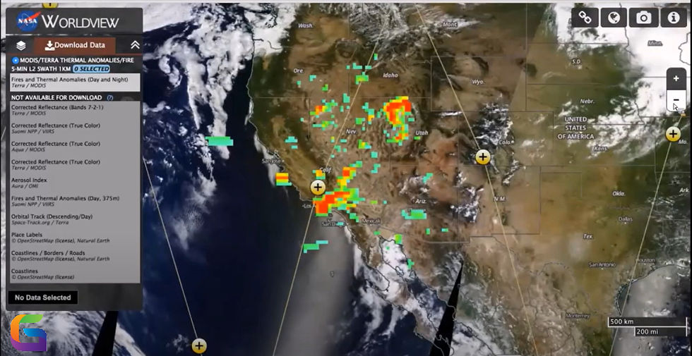
NASA's Earth Observing System Data and Information System (EOSDIS) created the interactive web program known as NASA Worldview. Users can view satellite imagery from NASA's Earth science satellites within hours of observation, with availability frequently occurring as quickly as three to four hours after observation.
With Worldview's user-friendly access to hundreds of satellite layers, users can investigate phenomena such as:
Smoke plumes and wildfires
Dust storms
Tropical cyclones
Deforestation
Changes in sea ice
Eruptions of volcanoes
Data on atmospheric conditions and air quality
Key Features of NASA Worldview
Real-Time and Near Real-Time Imagery
Near real-time (NRT) imagery from NASA's MODIS, VIIRS, and other satellite sensors is accessible through Worldview. For time-sensitive applications, such as catastrophe monitoring and rapid environmental assessments, this makes it indispensable.
Multi-sensor and Multi-layer Support
Numerous sensors and satellites are supported by Worldview, including:
MODIS (Terra and Aqua)
VIIRS (NOAA-20 and Suomi NPP)
TROPOMI (Sentinel-5P)
Himawari-8 (geostationary imaging) and GOES.
To gain insights from a variety of environmental indicators, like the aerosol index, sea surface temperature, land surface reflectance, and more, users can overlay numerous data layers while modifying the opacity and time range.
Interactive Map Interface
With the use of the application's incredibly responsive online interface, users can:
Zoom in and out of the world's images
Examine datasets from many periods.
Animate pictures over time.
Distribute or obtain high-quality pictures.
Locate coordinates with extreme precision.
Download and API Access
For use in GIS integration or additional geographical analysis, users can download imagery in GeoTIFF, PNG, and KMZ formats. The GIBS (Global Imagery Browse Services) API can be integrated by advanced users to automate the retrieval of images in custom platforms or apps.
Applications of NASA Worldview
Numerous fields make use of NASA Worldview, including:
Disaster Management
To help with quick reaction and resource allocation, emergency organizations monitor hurricanes, floods, wildfires, and other natural catastrophes using real-time satellite data.
Environmental Monitoring
Scientists examine how flora, ocean temperatures, ice cover, and air pollution have changed throughout time on a worldwide scale.
Geospatial Intelligence
In order to identify spatial patterns and perform predictive modelling, GIS experts and analysts incorporate Worldview data into mapping systems.
Educational and Public Use
Worldview is used by educators and the general public to teach science and increase knowledge of current environmental events, climate change, and Earth systems.
How to Use NASA Worldview: Step-by-Step
https://worldview.earthdata.nasa.gov is the URL.
Browse Layers: Select from more than 900 layers of worldwide satellite images.
Modify Timeframe: Choose particular dates or gradually animate images.
Overlay Data: Compare datasets and apply several environmental layers.
Export or Share: Download images or generate shareable links with your configured map.
Why NASA Worldview is Essential in 2025 and Beyond
Real-time Earth observation systems such as NASA Worldview offer the openness, accessibility, and immediacy required for actionable insights as climate variability, extreme weather, and environmental degradation increase in frequency.
Integrating Worldview's satellite data is increasingly becoming a crucial part of contemporary geospatial intelligence systems, especially when combined with developments in machine learning, edge AI, and geospatial analytics.
NASA Worldview is more than just a viewer; it's a portal to high-impact, real-time Earth data that helps scientists, analysts, and people around the world better understand our planet. For satellite-based Earth observation, Worldview offers a dependable, engaging, and technically sound platform, whether for scientific research, emergency response, or public awareness.
For more information or any questions regarding satellite imagery, please don't hesitate to contact us at
Email: info@geowgs84.com
USA (HQ): (720) 702–4849
India: 98260-76466 - Pradeep Shrivastava
Canada: (519) 590 9999
Mexico: 55 5941 3755
UK & Spain: +44 12358 56710


Comments