Dead Sea Coordinate Map for GIS and Geospatial Applications
- Anvita Shrivastava

- Jan 2
- 3 min read
The Dead Sea coordinate map is a critical geospatial resource for professionals working in GIS, remote sensing, surveying, environmental science, and spatial analysis. Located at the lowest exposed elevation on Earth, the Dead Sea presents unique cartographic and geodetic challenges that require precise coordinate systems, accurate projections, and consistent spatial referencing.
This technical guide explores how Dead Sea coordinate maps are used in GIS and geospatial applications, covering coordinate reference systems (CRS), projections, elevation modeling, and best practices for high-accuracy mapping.
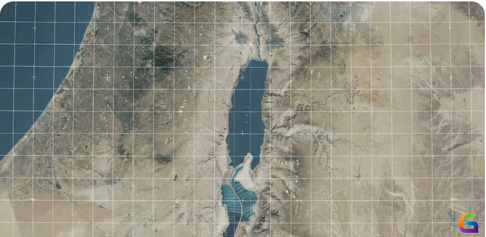
Understanding the Geographic Context of the Dead Sea
The Dead Sea lies between Israel and Jordan, extending roughly from 31.1° to 31.6° N latitude and 35.2° to 35.6° E longitude. What makes it geospatially unique is its extreme elevation:
Average surface elevation: ~-430 meters (-1,411 feet) below mean sea level
Constant shoreline change due to evaporation and reduced inflow
Rapid sinkhole development is affecting land stability.
These characteristics make accurate GIS mapping essential for environmental monitoring, infrastructure planning, and scientific research.
Common Coordinate Systems Used for Dead Sea Mapping
Geographic Coordinate System (WGS 84)
The most widely used system for Dead Sea GIS data is WGS 84 (EPSG:4326).
Uses latitude and longitude
Global standard for GPS and satellite imagery
Ideal for data exchange and web mapping
Example Dead Sea coordinates (WGS 84):
Latitude: 31.5° N
Longitude: 35.4° E
While WGS 84 is essential for interoperability, it is not always ideal for distance or area calculations.
Projected Coordinate Systems (UTM Zones)
For spatial analysis, the Dead Sea is typically mapped using UTM Zone 36N (EPSG:32636).
Advantages:
Metric units (meters)
Reduced distortion at the regional scale
Compatible with engineering and environmental studies
UTM projections are commonly used in:
Hydrological modeling
Infrastructure development
Land deformation analysis
Local and National Coordinate Systems
Depending on the jurisdiction, local systems may be required:
Israel Transverse Mercator (ITM – EPSG:2039)
Palestine 1923 / Palestine Grid
Jordan Transverse Mercator (JTM)
These systems provide higher accuracy for cadastral mapping and government-regulated GIS projects.
Elevation and Vertical Datums at the Dead Sea
Why Vertical Datums Matter
The Dead Sea’s extreme negative elevation introduces complexities in vertical referencing.
Common vertical datums include:
Mean Sea Level (MSL)
EGM96 / EGM2008 geoid models
Local leveling benchmarks
Because the Dead Sea is below global sea level, elevation values must be carefully interpreted to avoid errors in:
Flood modeling
Terrain analysis
Engineering design
Digital Elevation Models (DEMs)
High-resolution DEMs are critical for Dead Sea applications:
SRTM (30 m resolution) – widely used, moderate accuracy
ASTER GDEM – higher resolution, variable quality
LiDAR-based DEMs – highest accuracy for local studies
GIS Applications of Dead Sea Coordinate Maps
Environmental Monitoring
Shoreline retreat analysis
Sinkhole detection and risk assessment
Water level change modeling
GIS time-series analysis relies heavily on consistent coordinate systems to track spatial change over decades.
Remote Sensing and Satellite Analysis
Dead Sea studies commonly use:
Landsat
Sentinel-2
MODIS
Accurate georeferencing ensures:
Correct pixel alignment
Reliable change detection
Cross-sensor data integration
Urban and Infrastructure Planning
Coordinate maps support:
Road and pipeline routing
Tourism infrastructure planning
Hazard zone mapping
Using a projected CRS minimizes distortion for distance and area calculations.
Scientific and Geological Research
Geospatial datasets help analyze:
Tectonic movement along the Dead Sea Transform Fault
Ground subsidence
Mineral extraction impacts
High-precision coordinate mapping is essential for reproducible research.
Best Practices for Using Dead Sea Coordinate Maps in GIS
Always define the CRS explicitlyNever assume coordinate systems—misalignment can lead to errors of hundreds of meters.
Use projected systems for analysis. Prefer UTM or local grids for measurements and modeling.
Validate vertical datums. Confirm whether elevation data is ellipsoidal, geoid-based, or locally referenced.
Account for temporal changeShorelines and elevation change rapidly—timestamp your datasets.
Cross-check with authoritative sourcesUse national mapping agencies or scientific institutions for reference data.
Data Sources for Dead Sea Coordinate Maps
Reliable GIS data can be obtained from:
National mapping authorities (Israel and Jordan)
NASA and USGS EarthExplorer
Copernicus Open Access Hub
Academic and environmental research institutes
Ensure licensing and metadata are reviewed before integration into professional workflows.
A Dead Sea coordinate map is far more than a simple geographic reference—it is a foundational element for GIS and geospatial applications operating in one of the most dynamic landscapes on Earth. By choosing the correct coordinate system, projection, and vertical datum, professionals can ensure spatial accuracy, analytical reliability, and long-term data usability.
Whether you are conducting environmental monitoring, remote sensing analysis, or infrastructure planning, understanding Dead Sea coordinates is essential for producing high-quality geospatial outcomes.
For more information or any questions regarding the coordinate maps, please don't hesitate to contact us at
Email: info@geowgs84.com
USA (HQ): (720) 702–4849
India: 98260-76466 - Pradeep Shrivastava
Canada: (519) 590 9999
Mexico: 55 5941 3755
UK & Spain: +44 12358 56710


Comments