
How AI-Driven Satellite Imagery Technology Is Transforming Land-Use Planning

Land use planning has important significance in handling the city growth process, as well as the conservation of natural resources and sustainable development. In order for cities to develop in changing environmental conditions, planners make effective choices provided that they have valuable, current, and precise geospatial data at their disposal. The traditional mapping approach for land use is based on field surveys, manual interpretation of information, and unreliable geographical datasets, which makes it complicated for planners to supervise large areas.
AI-driven satellite imaging technology is changing this process due to the merging of Earth observation data, machine learning, and GIS. With the help of these tools, planners are in a position to carry on such actions as the making of land cover classification, detection of changes, and identifying the field trends by analyzing high rates of data over wide territories.
Having satellite images along with AI technology-based geospatial analytics, organizations may improve land assessments, speed up planning processes, and make decisions based on the data they have received.
What Is AI-Powered Satellite Imagery?
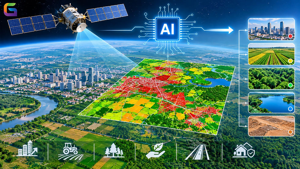
Artificial Intelligence-based Satellite Imaging refers to the use of machine learning and Artificial Intelligence technology in processing, analyzing, and understanding satellite imagery by identifying geographical objects in raster images, interpreting them, and deriving useful conclusions from the image datasets that otherwise require extensive manual work.
Satellite images obtain information about the Earth's surface based on a variety of spectral bands such as visible light, near-infrared, shortwave infrared, and thermal wavelengths. Through these spectral dimensions, AI algorithms process, analyze, and identify different geographic features such as:
Urban objects such as buildings, roads, etc.
Agricultural areas.
Forests, wetlands, and water bodies.
Industrial sectors and construction areas.
Bare soil, mining areas, and unimproved land.
Coastal regions and flood-prone areas.
In order to extract complex structural features from satellite images, deep learning algorithms such as CNNs, U-Net, and Vision Transformers can be applied in the process of analyzing satellite images for automatic land classification, object detection, land-use, and movement detection.
If combined with GIS systems, AI-based data can serve as a source of information for spatial analysis and land-fitting studies.
How AI and Satellite Imagery Work Together in Land-Use Planning
AI-based land-use analysis consists of several steps, including obtaining satellite data, using geospatial modelling, and then visualizing the results.
The process starts with obtaining satellite images of Earth from deployed satellites. Satellite systems differ by spatial, spectral, and temporal resolution.
Typical satellite imagery sources include:
Landsat: is used for the collection of cross-spectral images used for land cover study and environmental monitoring.
Sentinel-2: provides cross-spectral images that can be employed for vegetation assessment, agricultural analysis, and urban planning.
WorldView: is used for mapping details of infrastructure and investigating urban development.
PlanetScope: allows continuous monitoring of changes in land use.
Satellite Data Acquisition
This step begins with obtaining satellite images from Earth observation satellites. Different satellite systems offer images with varying levels of spatial, spectral, and temporal resolution.
Some examples of satellite data sources are:
Landsat: Provides multispectral images for the purpose of monitoring land cover and conducting environmental studies.
Sentinel-2: Provides images for monitoring vegetation, assessing the agricultural situation, and mapping cities.
WorldView: It provides images with high resolution for mapping infrastructure and assessing urban development.
PlanetScope: It allows for continuous observation of land-use changes and construction works.
The type of satellite images will depend on the area of study, required spatial resolution, observation frequency, and objectives of the analysis.
Image Enhancement
Satellite images need to be processed before using AI programs to achieve quality and uniformity of the data.
The most common preprocessing tasks are:
Radiometric correction: corrects the readings from the sensor in order to reduce inconsistencies in the radiometric values.
Atmospheric correction: removes the effects of the atmosphere due to the aerosols, water vapor, and more factors.
Geometric correction: turns images into a certain geographical coordinate system and eliminates spatial distortions.
Cloud masking: detects and eliminates all pixels covered with clouds and covered by cloud shadows.
Image normalization: processes the pixel values to ensure good performance of the system.
Image mosaicking: unifies several satellite pictures into one continuous coverage of the area.
All the stated tasks ensure that the AI models receive the same and reliable input data for their work.
Classification of Land Cover Using AI
One of the most significant uses of AI in land-use planning is land-cover classification.
Several models based on machine learning and deep learning techniques are used to classify pixels in satellite images into a certain land-cover type based on spectral features. Namely, the system can tell differences between populated areas, vegetation, farmland, water, and bare land.
The following algorithms are the most popular:
AI Algorithm | Application |
Random Forest | Land-cover classification using spectral and spatial features |
Support Vector Machine (SVM) | Classification of different land-cover categories |
CNN | Extraction of spatial features from satellite images |
U-Net | Pixel-level semantic segmentation |
Vision Transformer (ViT) | Learning complex spatial relationships in imagery |
The final land-cover classification enables planners to assess the current land-cover situation and select territories for future developments.
Change Detection and Temporal Analysis
Change in land use occurs over time due to urbanization, agricultural development, deforestation, construction of infrastructure, and environmental changes.
AI-enabled change detection techniques compare satellite imagery captured at different moments to pinpoint areas of change in the landscape.
For example, an AI system can discover:
Transition of agricultural land into residential land.
Urban expansion.
Decrease in forest cover.
Alteration of lakes and wetlands.
Construction along transport routes.
Changes in mining and industrial regions.
Time series analysis makes it possible to continuously observe the introduced changes and spot emerging trends.
Integration of GIS and Spatial Visualizations
The output generated by AI technology can be used in GIS systems for analysis and visualization.
Maps pertaining to land cover classification, building outlines, and results arising from change detection can be saved in either raster or vector layers.
The implementation of GIS tools offers the opportunity to overlay administrative borders, building networks, zoning laws, elevation, and sustainability into the application of these datasets.
Such integration makes land use appraisal more comprehensive and enables decision-makers to evaluate developments based on geographic evidence.
Important AI Techniques Used in Satellite Image Analysis
Different AI techniques are used depending on the type of land-use information required.
AI Technique | Role in Land-Use Planning |
Machine Learning | Classifies land-cover types using spectral and spatial data |
Deep Learning | Extracts complex features from high-resolution satellite imagery |
Semantic Segmentation | Assigns land-cover categories to individual pixels |
Object Detection | Identifies buildings, roads, vehicles, and infrastructure |
Change Detection | Identifies differences between multi-temporal satellite images |
Time-Series Analysis | Monitors seasonal and long-term land-use patterns |
Predictive Modeling | Estimates potential future land-use changes |
For large-scale projects, combining multiple techniques can improve classification accuracy and provide more comprehensive information about changing landscapes.
Benefits of AI-Powered Satellite Imagery for Land-Use Planning
Using AI technology in satellite imagery brings numerous benefits.
Increased Accuracy in Mapping
The technologies used in AI can identify sophisticated geographic features based on the information used. Namely, training the machine using accurately labeled and representative datasets can enhance precise land cover and effective feature extraction.
Faster Geospatial Analysis
The automation of image processing facilitates the reduction of human intervention in the interpretation processes of extensive amounts of data. This makes it easier for organizations to process information about huge areas of land.
Constant Monitoring of Land Use
Regular observations with the help of satellites can facilitate effective monitoring of changes on the land over time. This applies to cases of urban growth, deforestation, converting land into agriculture, or construction.
Affordable Large-Scale Assessments
Satellite imagery allows for widely available geographic coverage without the need for ground surveys at every specific site. The deployment of artificial intelligence can also save even more time and resources in terms of conducting recurrent land-use evaluations.
Data-Motivated Decision Making
When GIS data is integrated with the information generated by artificial intelligence, it creates measurable spatial data that can be used by planners to make better decisions on issues like zoning, investment in infrastructure, environmental protection, and land allotment.
Challenges of Using AI in Satellite-Based Land-Use Planning
Although AI has many benefits, when it comes to putting AI-supported satellite analysis into effect, it is important to pay attention to the data quality, model performance, and operational limitations.
Satellite Image Resolution: Medium-resolution images may not be able to spot small buildings, thin roads, or complicated infrastructure components, and high-resolution images may be needed for a location-specific study.
Cloud Cover and Atmospheric Conditions: Cloudiness, shadows, haze, and seasonal changes can affect image quality and reduce the reliability of classification.
Availability of Training Data: AI algorithms must work with representative and adequately labeled training datasets. If insufficient training data are available, land cover predictions prove to be inaccurate.
Model Generalization: A model that can be adjusted to one specific geographic region may not perform well in another area because of the climate, type of vegetation, construction materials used, and many other issues relating to the particular landscape.
Data Integration: Integrating satellite images that come from various sensors and at different times poses challenges related to the differences in the coordinate systems and resolutions of the input data and the ways they should be preprocessed.
Computational Requirements: Processing large volumes of high-resolution imagery requires sufficient storage, memory, processing power, and scalable computing infrastructure.
Validation and Accuracy Assessment: AI-generated maps should be validated using reliable reference data, field observations, or independent datasets before being used for important planning decisions.
Addressing these challenges requires a combination of reliable satellite data, appropriate AI models, GIS expertise, and human validation.
Geospatial planning is embarking on a whole new journey, thanks to AI-based satellite imaging that is advancing the analytics of geospatial data. Machine learning, deep learning, change detection techniques, and GIS integration are assisting planners with analyzing urbanization, establishing land for agricultural purposes, spotting changes in an environment, and defining the suitability of land for construction projects.
Despite some limitations that remain in the fields of image clarity, data quality, model efficiency, and computational power, the new opportunities for conducting large-scale geospatial analysis are created by advances in cloud computing and GeoAI technologies.
In the course of improving satellite observation techniques and AI algorithms, the technology of intelligent analysis of satellite images could become increasingly vital for solving urban sustainability, preserving ecologies, and managing land use.
Nowadays, the collaboration between geospatial companies and planners in the environmental field is based on intelligent analysis of satellite images and available GIS technology.
For more information or any questions regarding Satellite Imagery, please don't hesitate to contact us at
Email: info@geowgs84.com
USA (HQ): (720) 702–4849
India: 98260-76466 - Pradeep Shrivastava
Canada: (519) 590 9999
Mexico: 55 5941 3755
UK & Spain: +44 12358 56710


Comments