What Is Pan-Sharpening in Remote Sensing and GIS?
- Anvita Shrivastava

- 2 days ago
- 5 min read
In remote sensing and GIS, image quality is key to mapping, analysis, and decision-making. There are basically two types of satellite imagery: high resolution (panchromatic) and low resolution (multispectral). While both types of imagery are useful, neither provides the best balance between spatial detail and spectral accuracy by itself.
This is where pan sharpening comes in.
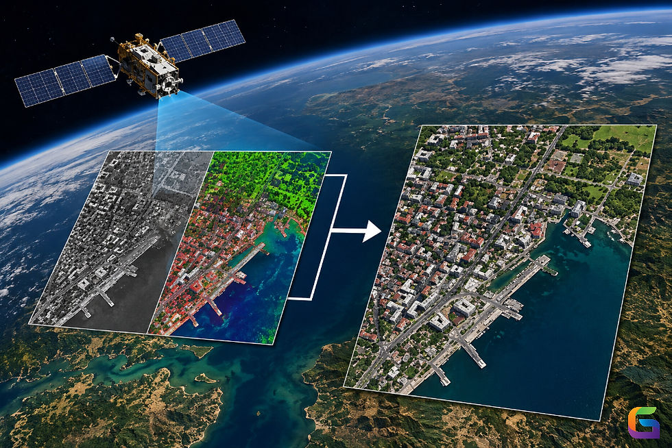
Pan sharpening is a common image fusion technique that produces a single image that contains the sharp spatial detail of a panchromatic image and the abundant spectral information of a multispectral image. This image is extremely useful for GIS applications, urban planning, environmental monitoring, and precision agriculture because it has both sharp visual detail and accurate color representation.
What Is Pan-Sharpening?
Pan-sharpening is a way to create an image from two images:
A high-resolution panchromatic (PAN) image
A low-resolution multispectral (MS) image
The reason for pan-sharpening is to create a multispectral image that has a finer spatial resolution than the multispectral image originally had, but that retains the original multispectral image's spectral properties.
Example
Consider imagery from a satellite sensor:
Image Type | Resolution |
0.5 meters | |
Multispectral | 2 meters |
After pan-sharpening, the multispectral image will be sharper than it was before, because it will have the added sharpness of the panchromatic image, but will retain the color information from the multispectral image.
What Are Panchromatic and Multispectral Images?
Panchromatic Images
A panchromatic image is an image that consists of reflected energy recorded in several wavelengths and is displayed as a grayscale image.
Characteristics of Panchromatic Images:
Higher resolution than multispectral images
Higher sharpness of the image
Better capacity to detect objects
Limited spectral information available from a panchromatic image
Multispectral Images
Multispectral images are used to collect data in more than one wavelength, and some of the bands of wavelengths included in the collection of multispectral images include:
Blue band
Green band
Red band
Near infra-red band
Short-wave infra-red band
Characteristics of Multispectral Images:
Provide a lot of information in the spectral range.
Can be classified and analyzed
Has a lower resolution than a panchromatic image
Pan-sharpening combines the useful features from both types of images.
How does pan-sharpening work?
Pan-sharpening is a way to add spatial detail from panchromatic images to multispectral images.
Basic workflow of pan-sharpening:
Get a panchromatic and multispectral image from the same camera.
Align and register both images.
Resample the multispectral image to PAN resolution.
Run a pan-sharpening algorithm.
Produce a high-resolution multispectral image.
Assess quality and perform validation.
The result is an image that has enhanced spatial resolution but maintains the original spectral properties.
Common Pan-Sharpening Techniques
There are many different pan-sharpening methods available, and each method has its pros and cons.
IHS (Intensity-Hue-Saturation)
The IHS method converts RGB imagery into an intensity component, a hue component, and a saturation component. The intensity component is replaced by the panchromatic image, then the intensity, hue, and saturation are combined and converted back into 3-band RGB imagery.
Pros:
Fast
Visually appealing
Easy to implement
Cons:
Spectral distortion
Limited to 3-band imagery
PCA (Principal Components Analysis)
The PCA method will produce principal components for each of the multispectral bands and will correlate those components together into a PCA image. Then the first principal component will be replaced with the pan image, and then the PCA image will be transformed back into an RGB image using inverse PCA transformation.
Pros:
Good at data compression
Commonly used in remote sensing, a lot of literature supports this approach.
Cons:
Can cause a color shift in the image
Can change the spectral response of the multispectral image
Brovey Transform
The Brovey Transform uses a ratio-based approach to combine panchromatic and multispectral bands.
Pros:
Produces visually sharp images
Best for visualization purposes
Cons:
Freedom of using spectral info being altered
Poor Quantitative Analysis Capability
Gram-Schmidt Pan-Sharpening
The most popular method is found within commercial GIS infrastructure.
Pros:
Ability to maintain strong spectral information
High-end usage quality
Allows for analytical workflows
Cons:
Highly computationally intensive
Wavelet-Based Pan-Sharpening
Wavelet transforms are used to add spatial context while not heavily compromising on maintaining some level of spectral information.
Pros:
Spectral information is exceptionally well maintained.
High-end quality of the final product
Cons:
Implementing is more complex.
Higher computational resource demand
Why Is Pan-Sharpening Important in GIS?
GIS experts typically require imagery that has both detailed image characteristics and accurate spectral information.
Through the process of pan-sharpening, you will be able to achieve:
Enhanced Visualization
Sharper Maps
More Precise Interpretation of Features
Higher Quality Presentation of Imagery
Improved Feature Extraction
Analysts can more accurately identify:
Buildings
Roads
Utility Networks
Vegetation Boundaries
with greater precision.
Better Mapping Accuracy
Digitising Workflows
Land Use Mapping
Infrastructure Inventories
Supporting Spatial Analysis
Many GIS analyses will use clarity to assist with performing a large portion of their analysis, especially in urban environments.
Applications of Pan-Sharpening
Urban Development
Planners use pan-sharpened imagery to:
Tracking the progression of cities
Identifying new building sites
Refresh prior base maps.
Agricultural
The basis for Precision Agriculture is the use of high-resolution photography.
Monitoring if crops are healthy
Determining if irrigation works
Identifying crop stress patterns
Environmental Monitoring
Examples of this include:
Deforestation tracking.
Wetlands mapping.
Animal Habitat monitoring.
Emergency Response support
Pan-sharpened imagery supports:
Flood prediction
Evaluation of earthquake damage
Monitoring wildfires
Transportation and Infrastructure
Engineers will use enhanced imagery to map:
Roads.
Railroads.
Utility line corridors.
Construction zones.
Advantages of Pan-Sharpening
A higher level of spatial detail, which improves the accuracy of the classification and location of objects on the map.
A higher level of visual interpretation (more real and more beautiful).
Improved GIS workflows include better capabilities for digitizing, classifying, and extracting features.
Cost-effective near- high-resolution multispectral imagery is achieved through the use of an auxiliary and/or additional acquisition for this application area.
Limitations of Pan-Sharpening
Pan-sharpening is not without limitations.
Altered Spectral Values
Certain pan-sharpening techniques may change the original spectral values.
Dependence on Algorithms
The quality of the output images will depend greatly. on which pan-sharpening method was chosen.
Suboptimal for Certain Analyses
If a scientific application needs very precise measurements of the original spectral values for an analysis, it will probably prefer to use the original multispectral images.
Increased Computational Resources
Large datasets generated from pan-sharping can be more resource-intensive than other types of processing.
Future Trends in Pan-Sharpening
Emerging technologies are enabling pan-sharpening to perform more adequately in the future. These include:
Artificial Intelligence
As artificial intelligence becomes more sophisticated, new and improved deep learning models are being developed to:
Reduce spectral distortion
Improve image quality
Automate the process of fusing images.
Machine Learning Fusion
Using complex algorithms, machine learning is now coming into its own as it has the ability to learn the relationship between PAN imagery and multispectral data to allow an improved statistical means of integrating them into one image.
Real-Time Processing
Cloud computing allows for the rapid fusion of images, creating efficiencies in GIS operational workflows.
Pan-Sharpening has become a core technology of the remote sensing and GIS field by fusing the spatial detail available in the panchromatic images with the spectral richness available in multispectral images. Using this technique, geographic and spatial data can now be obtained a long way before by providing resolutions superior to the original images while preserving the colour data associated with both types of images, thus improving mapping, visualisation, and spatial analysis across various industries (e.g., urban planning, agro-industrial, environmental management, and disaster-response).
As satellite imagery improves and artificial intelligence-based processing becomes more prevalent, pan-sharpening will remain important for all geospatial professionals who require quality imagery for advanced GIS applications.
For more information or any questions regarding Pan-Sharpening, please don't hesitate to contact us at
Email: info@geowgs84.com
USA (HQ): (720) 702–4849
India: 98260-76466 - Pradeep Shrivastava
Canada: (519) 590 9999
Mexico: 55 5941 3755
UK & Spain: +44 12358 56710

Comments