Leveraging Aerial Photogrammetry for Surveying, Mapping, and GIS Applications
- Anvita Shrivastava

- Oct 30, 2025
- 3 min read
Updated: Apr 14
The geospatial industry moves quickly, and accuracy and speed are vital. Aerial photogrammetry is a game changer, changing how surveyors, cartographers, and GIS specialists gather, analyse, and visualise spatial data. This blog will explore the advantages of aerial photogrammetry over surveying, mapping, and GIS applications and why it is an invaluable tool for contemporary geospatial projects.

What is Aerial Photogrammetry?
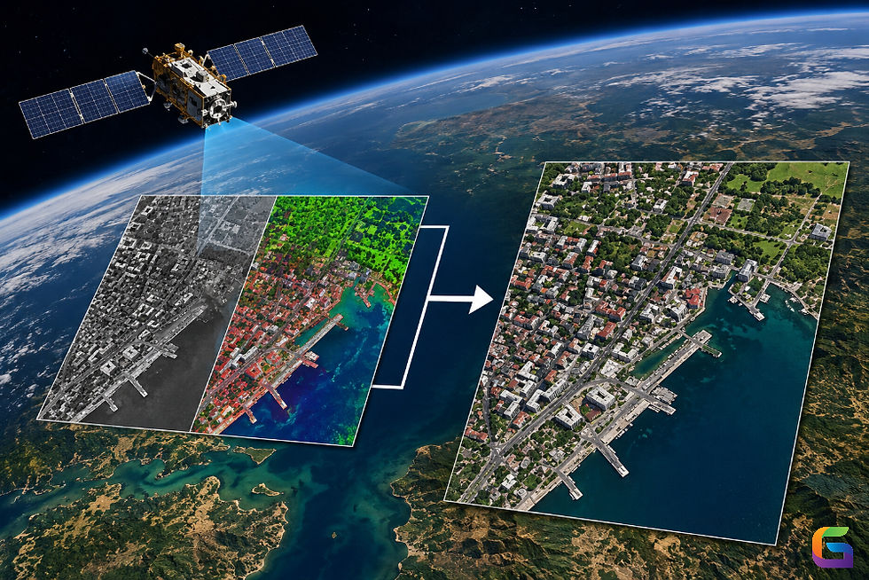
Aerial photogrammetry is the science of taking accurate measurements and 3D information from above using images taken by drones, aeroplanes, or satellites. Photogrammetry software analyses several overlapping images to reconstruct the geometry of objects and terrain to create highly accurate maps, 3D models, and digital elevation models (DEMs).
Aerial photogrammetry can cover large areas rapidly, reducing labour costs and time while maintaining accuracy over traditional ground surveying methods.
Uses in Surveying
Surveying is one of the most important geospatial activities because it involves highly accurate measurements of location, land, infrastructure, and natural resources. Aerial photogrammetry provides several advantages for surveying:
Topographic Surveys: Quickly produce detailed contour maps and digital terrain models.
Volume Calculations: Accurately calculate tonnage of stockpiles and estimate excavation of earthen materials at a borrow site for a mining or construction project; comparable for landfills and recycling of inert fill materials.
Land Parcel Mapping: Provides enough accuracy for improved cadastral surveys for determining parcel boundaries.
Infrastructure Monitoring: Provides sufficient accuracy to be able to monitor the condition of a road, bridge, or pipeline without requiring a significant amount of field effort.
Mapping and Cartography
An accurate map is a prerequisite for urban planning, environmental studies, and resource management. Aerial photogrammetry extends the capabilities of mapping by:
High-Resolution Orthomosaics: Integrate and stitch multiple aerial images to produce a complete high-resolution surface map.
3D Modelling of Terrain and Buildings: Visualise a building, standing trees, or topography in 3 dimensions.
Change Detection: Evaluate historical data obtained from aerial surveys, and inspect current data from subsequent aerial surveys to track urban expansion, deforestation, or erosion.
Disaster Management Mapping: Generate a rapid map with spatial information after a major disaster event, following a flood, earthquake, or landslide.
When paired with ground survey locations, aerial photogrammetry can create extremely precise digital terrain models that are used in engineering design and construction to create infrastructure, including buildings, roads, and water management systems.
Integration with GIS Applications
Geographic Information Systems (GIS) require accurate geographic data to analyse possible patterns, trends, and relationships. Aerial photogrammetry offers the GIS community:
Highly Accurate Georeferenced Data: Input your orthomosaics and 3D derived models directly into any GIS for analysis.
Environmental Monitoring: Observe changes to vegetation, lakes, or wildlife habitat over time.
Urban Planning: Provides spatial data for smart city applications that are always up to date.
Infrastructure Asset Management: Map and maintain your utilities, transportation networks, and public asset management efficiently.
The Benefits of Aerial Photogrammetry
Speed and Efficiency: Survey a large area in hours instead of days.
Cost Effectiveness: Reduce labour, equipment, and fieldwork costs.
High Accuracy: Get centimetre accuracy for critical projects.
Safety: Decrease risk to personnel by limiting fieldwork due to dangerous or inaccessible areas.
Versatility: Applicable across many sectors, including construction, agriculture, forestry, mining, and urban planning.
Future Predictions
As drones become more common in our society, along with photogrammetry software powered by AI and GIS integration in real-time, aerial photogrammetry will become even more accurate and accessible. New technologies, like LiDAR integration and auto-change detection, will improve surveyors, mappers, and GIS professionals' experiences even more.
Aerial photogrammetry is not simply an option anymore; it is needed to represent anyone involved in surveying, mapping, or GIS. Its ability to deliver high-resolution, accurate, and georeferenced spatial data quickly and safely gives professionals the information they need to make well-informed choices, optimise workflows, and explore contemporary geospatial analysis.
For more information or any questions regarding aerial photogrammetry, please don't hesitate to contact us at
Email: info@geowgs84.com
USA (HQ): (720) 702–4849
India: 98260-76466 - Pradeep Shrivastava
Canada: (519) 590 9999
Mexico: 55 5941 3755
UK & Spain: +44 12358 56710


Comments